Around 20,000 years ago, during the Ice Age, a fertile ground moraine was formed that extended northwards towards the Baltic Sea. At a distance of a few hundred metres from the coast, heights of more than 50 metres rise, such as in our neighbouring village of Wohlenhagen.
The area on the Wohlenberger Wiek was already inhabited by people in prehistoric times, as evidenced by the Bronze Age burial mounds in our neighbouring village of Wohlenhagen. The presumably Slavic hillfort in neighbouring Wohlenberg shows that this area was also inhabited during the Slavic settlement period.
However, agriculture and livestock farming were the main features of our landscape. Hedges separated the fields of the individual villages from each other, while the first paths connected the villages.
Like most places in north-western Mecklenburg, the villages (…) arose in the course of German colonisation in the east at the beginning of the 13th century. Groß Walmstorf is mentioned as Walmanstorp in the Ratzeburg tithe register of 1230. The same applies to Niendorf, which was called Nova Villa around 1230 and Nyndorpe around 1299. (…)
The peasants recruited to colonise Mecklenburg in western Germany were personally free. However, their originally favourable legal position changed over the following centuries as the knighthood gained in power and influence. From the 16th century onwards, the knights expanded their initially modest landholdings and switched to manor farming.
After the introduction of serfdom in the 17th century, the peasants were personally and economically unfree and could be driven from their farms. After the Thirty Years’ War, the deserted farms in the largely depopulated country were initially assigned to the estates. Then entire farming villages were laid out and incorporated into the estate.
The Wohlenberger Wiek was only used for tourism by the locals.
Since the Middle Ages, Wismar’s fishing rights had extended to the Boltenhagener and Wohlenberger Wiek as well as the Golwitz, the Breitling and biS Wustrow, while the inhabitants of the Stranddöder were only allowed to fish from the beach or with static nets. There had always been disputes about this.
From the middle of the last century, fishing on Poel developed into an independent line of business, which was practised all year round, especially by younger farmers’ sons. The same happened in other beach villages.
In 1897, it was finally decided that the bay would be divided into fishing grounds, the fishing of which would alternate between the fishermen of Wismar, Poel and the other beach villages up to Alt Gaarz. The two small islands that still existed in the bay in the Middle Ages, the Lieps and the Holm = Walfisch, were no longer used as the council’s horse pasture.
Mecklenburg has always been an agricultural region in which the peasantry was the predominant social and economic group. The ownership of land was repeatedly the subject of disputes.
The Thirty Years’ War from 1618 to 1648 had a decisive influence on the agricultural economy. As a result of the devastation of farmland and the destruction of farms, agricultural estates were initially abandoned and later greatly enlarged by peasant settlements.
This led to significant shifts in land ownership, both within the nobility and among the peasants. Noble families died out, ownership changed hands frequently due to bankruptcies, and new land was granted to fewer owners.
Individual families acquired entire estates and the associated villages through the purchase of war profiteers, especially noble officers in the higher service. Previously, villages had often belonged to different lords, but now large, contiguous estates emerged. These strengthened landowners now had more power over the peasants.
Source: Historical map 1788 Schmettau University of Rostock (GAIA MV)
The war led to widespread devastation, including burnt or badly damaged farms, lost livestock and fallow farmland.
This contributed significantly to the Ordinances of 1645 and 1654, which established the servitude and serfdom of peasants and subjects, including their families. The war had caused a significant shortage of peasants and the few survivors were dependent on the lords of the manor to restore their farms and procure livestock, seed and inventory.
As a result, in most cases the farms and the ‘Hofwehr’ (livestock, household and farming equipment and seeds) now belonged to the lords of the manor.
The storm surge of 12/13 November 1872 is the most severe storm surge recorded in the western Baltic Sea. Maximum peak water levels of around 3 metres above mean sea level were recorded.
The effects on the lives of the people and their surroundings were devastating.
The cause of the catastrophe was a swing back of the accumulated Baltic Sea water, a turn of the storm to the north-east and an increase in the wind to hurricane force.
Of course, this also affected the Wohlenberger Wiek. Most of our campsite was probably under water at that time. Only the roof of the central south sanitary block would still have been visible.
Sources: Wikipedia Further in Flyer of BSH, Norddeutscher Rundfunk (NDR)
Among the villages of the present-day municipality of Groß Walmstorf, several farms remained in Wahrstorf and Wohlenhagen in addition to the estates. Groß Walmstorf with the Niendorf outlying estate developed into a pure manor and came into the possession of the Lüneburg knighthood. Until the end of the 19th century there was still the Kl. Walinstorf estate. Its field was then annexed to Gr. Walmstorf.
Around the middle of the 19th century, Groß Walmstorf is described as an estate with a school, smithy and 112 inhabitants. Niendorf was a dairy of Groß Walmstorf with 74 inhabitants. (…)
There were plans to build a war harbour for a fleet of the German Confederation at the southern end of the Wohlenberger Wiek (HARKORT, 1864). However, this was never realised.
Apart from the dissolution of the Klein Walmstorf estate, little changed in the settlement structure until after the Second World War. In the period before the turn of the century, the area was opened up by country roads (Grevesmühlen-Hohenkirchen 1890 Wismar-Klütz 1897) and around 1920 it was connected to the electricity grid.
Source: Historic map 1888 Ordnance Survey maps University of Rostock (GAIA MV)
A significant turning point in the development of the villages was the expropriation of land over 100 hectares under occupation law after the Second World War. The Groß Walmstorf estate was first declared a state estate and then a state-owned estate around 1950. In the other three villages on the Wohlenberger Wiek, the estates were resettled in the course of the land reform and a large number of smallholdings were created.
Here is the last aerial photo before it was used as a campsite.
Source: State Office for Internal Administration Mecklenburg-Vorpommern Office for Geoinformation, Surveying and Cadastre
Due to the influx of refugees and displaced persons from the East, the population in the four villages of today’s municipality had risen from 397 inhabitants around 1935 to 1063 inhabitants in 1946.
In Groß Walmstorf, the village’s building structure was largely preserved, as the estate was not built on. A row of semi-detached houses was built along the village street and later a three-storey block of flats on the northern edge of the village. The estate’s farm buildings were extended with stables and workshops. In the other three villages, the townscape changed considerably after the division due to the construction of small new farmsteads and the demolition of farm buildings on the former estates.
In the course of the collectivisation of agriculture and the creation of new large farms, several LPGs (agricultural production cooperatives) were initially established after 1960 and later became the LPG Groß Warnow or, for example, were affiliated to the state-owned enterprise (VEB) Gr. Walmstorf.
The small village of Niendorf belonged to the municipality of Groß Walmstorf in the Grevesmühlen district of Rostock.
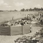
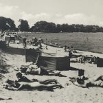
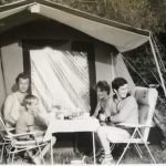
Camping, later called camping, also became more and more fashionable, especially among holidaymakers who were unable to find places in hostels or other accommodation, or who preferred this type of holiday. However, they had to adhere to strict rules and were only allowed to pitch their tents or caravans on state-run campsites, as the shores of the bay were part of the border area and were strictly monitored.
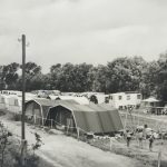
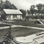
Since the end of the 1960s, tourism has become increasingly important in our municipality. The ‘Niendorfer Weg campsite’ was built on the unique Wohlenberger Wiek from 1965 and opened in 1968. The Free German Trade Union Federation (FDGB) holiday service from Halle and the Halle Meat Combine were the main drivers.
Only here is the water always 2° warmer than on other sandy beaches in the Baltic Sea due to the shallow depth.
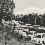
With increasing motorisation, the Wohlenberger Wiek developed into an important local recreation area for tourists from a wide area. In this context, the new beach road between Wahrstorf and Niendorf was built in 1972.
By the 1983 season, the Niendorfer Weg campsite had been enlarged and the quality improved at a cost of 2,400 TM in a 5-year plan. At the same time, the campsites in Binz and Lubmin, as well as Klütz, were closed. The GDR campsite Niendorfer Weg on the Wohlenberger Wiek had a capacity of 1,000 people until 1982 and around 2,500 from 1983.
Meanwhile, several company-owned recreational facilities were built in Niendorf and Wohlenhagen, including a cinema and two Konsum stores. Mrs Pflugmacher was the first manager and was later taken over by Mr Weißbrot.
Investments in TM (thousand Marks):
1978: 30
1979: 650
1980: 400
1981: 460
1983: 400
Recreation, relaxation and preservation of labour through an FDGB holiday trip
Until 1990, the FDGB holiday facilities in Niendorf and Wohlenhagen had up to 200 beds. There were a further 150 places for children in two holiday camps. There were also around 62 privately rented beds in the municipality. These capacities were fully occupied during the season when the GDR was closed to tourists.
However, for the most part, they were unable to fulfil the requirements after unification in terms of quality. The remodelling is still not completely finished. For the time being, the ostseequelle.camp will at least retain the access paths made of heavy concrete slabs ;-).
Source: With the kind permission of the Koppe family
However, the campsites had to adhere to strict rules and were only allowed to pitch their tents or caravans on the state-run campsites, as the shore of the bay was part of the border area and was strictly monitored.
Troops from the Coastal Border Brigade were stationed in Boltenhagen Tarnewitz and on Poel, as well as in the Rerik area. The Coastal Border Brigade was not allowed to leave anything to chance. An enormous control system was built up over the years. Large watchtowers, observation posts on the beach and a mobile searchlight crew. The water was illuminated in the evening. The floodlights had a range of up to three kilometres. The sea knew no darkness for decades.
In summer, the observation posts on the watchtowers were very popular. Bikini-watching at work. Nevertheless, a nudist culture developed. There are worse jobs. But in winter, the patrols were pretty tough. An icy wind blew in from the Baltic Sea. The eight-hour patrols were torture.
After reunification, the campsite was renamed ‘Campingplatz Niendorf’ at Strandstraße 21 on 6 May 1993 and continued to be run by Sabine and Wolfang Ehrlich (Sabine is the role model for our guest chatbot, always there for our guests). The municipality of Hohenkirchen was formed in 2005 from the previously independent municipalities of Groß Walmstorf and Gramkow. It is administered by the Klützer Winkel district council based in the town of Klütz. Here is a list of local architectural monuments.
Source: Historic Map 1991 (GAIA MV)
Various modernisations were introduced.
The Wohlenberger Wiek with its shallow beach and the sandbanks that fall dry at low tide is particularly suitable for families with children and water hikers. The 1 metre depth line is around 100-200 metres from the shore, so the shallow water warms up very quickly in the sunshine. Due to its location, the bay is well protected from frequent south-westerly and westerly winds. The shallow water offers many waterfowl a wide range of feeding opportunities. By relocating the L01 from the immediate beach area to the hinterland, the attractiveness of Wohlenberger Wiek could be significantly improved and the hinterland could be further developed for tourism in order to create jobs.
There are many car parks for day visitors, which are operated by the municipality for a fee.
Since 1 January 2020, the campsite has been managed by Alexander Ehrlich under the new name ostseequelle.camp. The acquired GmbH remains the leaseholder of the land. He is actively supported by his team and the whole family. More on our About us page. A modern barrier system with licence plate recognition was used right from the start. The system was supplemented with modern, albeit very error-prone, camping software. The ‘Camping.care’ software works best when the guests do everything themselves. And that’s how we still do it today. The online shop offers guests a lot of freedom.
Book 24 hours without waiting. Confirmation comes immediately after the deposit.
No registration or reception. Everyone can check in and check out themselves.
Arrivals from 1pm to 10pm, departures between 7am and 11am (pitches).
All-inclusive prices (WLAN, showers, 8kWh electricity included).
Paperless and partially automated administration.
The office staff are guest advisors and take care of you guests as well as changes and cancellations.
2021:
Review 2021
Renovation of the north men’s sanitary block
2022:
What’s new in 2022
Sustainability strategy
Expansion of fibre optic connection
2023:
New in 2023
We are now a purely tourist campsite.
There are no more seasonal contracts.
In 2023 we won the ADAC Camping Award,
as the only German campsite, the award is advertised throughout Europe.
2024:
New in 2024
Camping.info Award 2024
2026:
We will be n by 2026.
In the municipality, three prehistoric and early historical burial mounds in Wohlenhagen and a medieval fortified farmstead in the Schmiedewald forest near Groß Walmstorf are under protection. (…) Four massive farm labourers’ cottages of the former knightly estate of Groß Walmstorf are listed as architectural monuments.
Other buildings that characterise the village, which were not previously classified as monuments, should definitely be preserved in their external appearance. Examples include the manor house in Groß Walmstorf and the adjoining small park with valuable trees, as well as the remains of the estate complex in Wohlenhagen with the residential building, the two-storey granary and the large barn.
More about the municipality of Hohenkirchen today:
Population: 1259 (31.12.2019)
Area: 4109 ha